Guam Public Laws 24-247 and 24-161
In 1998, the 24th Guam Legislature enacted Public Laws 24-247 and 24-161 as the Guam Hydrologic Survey (GHS) and the Comprehensive Water Monitoring Program (CWMP), respectively. These two laws were ratified in response to an El Niño event in 1998, resulting in a prolonged drought that advised water rationing practices. CWMP addresses the need for continued collection of hydrologic data and GHS to conduct more hydrologic and water resources research. WERI is charged with administering the annual legislative appropriations necessary to facilitate, direct, and implement the program’s primary objectives. Both programs are now integral to the WERI water resources research, information dissemination, education, and training mission.
The foresight of the Guam Legislature in creating these two vital programs deserves special mention. Through their efforts and continued support, WERI advances in consolidating and interpreting several essential water resource information, constructing hydrologic information for Guam, and revitalizing the USGS water resource monitoring program. Our understanding of the complex physical, chemical, and biological processes that influence Guam’s water resources has broadened, and the increase in graduate student research opportunities provided by the programs contributed to the number of highly trained water resource professionals in the island’s workforce.
Guam Hydrologic Survey Program
The purpose of GHS is to consolidate all of Guam’s available hydrological data gathered by local and federal government agencies and consultants, and to conduct research on water-related issues of local importance. GHS also funds a variety of water resource educational programs in various formats, including guest lectures and seminars at UOG and in the community, informational and training workshops for teachers and professionals from other government agencies, field trips and talks for students, and the publication and distribution of educational posters, maps, and fact sheets. In addition, GHS also funds research assistants and associates who engage in CWMP activities, including fieldwork with USGS’ observation well data collection, and phreatic groundwater and hydrologic data analyses.
For twenty-eight years, WERI has continued to operate and administer the GHS Program. The GHS and CWMP Annual Reports are now available online on the GHS website: https://guamhydrologicsurvey.uog.edu
WERI serves numerous island agency partners through the GHS Program, attending legislative hearings, providing research findings, sharing hydrologic and geologic maps, and advising on water resource concerns. Through the GHS Program, reliable research-based information can be achieved. Therefore, the Guam Legislature, Guam Environmental Protection Agency (GEPA), Guam Waterworks Authority (GWA), NAVFAC Marianas, and the Groundwater Resources Development Group (GWRDG) are more confident in determining management plans, actions, and regulations involving our water resources. WERI shared water research findings and advised agencies on wastewater issues, aquifer capacity, hydrogeologic assessments, surface hydrology, saltwater intrusion, and the new online data visualization products.
WERI provided GHS outreach to the Northern Guam Soil and Water Conservation District, GWA, the Legislature, Guam DOE, visiting universities, and the private sector with the Virtual Tour into the Northern Guam Lens Aquifer. Post social distancing protocols, in 2024 the GHS Program, with the services of Global Learning and Engagement (GLE UOG), WERI resumed the Northern Guam Lens Aquifer Virtual and Site Tour.
WERI continues to expand GHS interagency support through its online web products. Since developing the GHS website in 2016, WERI manages and produce new hydrologic reports, presentations, maps, and databases. WERI continues to develop new online data visualization products—a new means of sharing hydrologic data through interactive maps and graphs, such as WERI Web MApps and MAppFx.
Comprehensive Water Monitoring Program (CWMP)
The CWMP is the core of essential water information, through approved measurements and analytic methods, the basis of hydrologic research interpretations. The CWMP was created to gather data on saltwater intrusion and water lens profiles in Guam’s sole source aquifer in the northern part of the island. Stream flow data and other parameters associated with surface waters are collected in the south. Moreover, the program collects rainfall data for hydrologic, meteorologic, and climatologic studies. These are essential for determining sustainability assessments and water supply capacities.
The CWMP rehabilitated data collection assets that fell into disrepair. CWMP allowed WERI to obtain services from USGS Pacific Island Water Science Center (PIWSC) to collect, organize, and manage hydrologic data from stream gages, rain gages, and observation wells. Government of Guam and USGS PIWSC funds the CWMP, restores the Federal/State Territory cost-sharing for continued hydrologic monitoring.
USGS PIWSC methods ensure that data are frequently and reliably collected, analyzed, and made widely available. Most data from USGS gages are readily accessible online. PIWSC collected hydrologic information for Guam are consolidated, quality is marked with provisional and approved, and made available online:
CWMP data is analyzed and interpreted. GHS employs research assistants and research associates to organize, analyze, and interpret CWMP data. CWMP is essential to GHS projects that processes, analyzes, and interprets the collected data.
GHS and CWMP Organization and Operations
GHS and CWMP are organized by a program management team that involves the WERI Director and a support panel of WERI Faculty subject experts, the Program Coordinator, Operations Manager, and the Program Advisor. The WERI GHS and CWMP Program continue to improve and may also change the internal organizational structure yearly to streamline operations, management, processes, and product output. The organization is also crucial for determining the program’s resource requirements, project focus, and annual budget. The figure below is an internal WERI GHS and CWMP personnel position and process diagram.
GHS analyzes water resource data for investigative research and the production of reports. WERI Faculty proposes GHS projects annually and selects the best available research assistants to conduct a GHS-related project. This opens opportunities for a research assistant to do a master’s thesis through UOG’s Environmental Science Program. GHS also has an Information Management team that oversees and develops both the WERI and GHS websites. The Operations Manager collects project summaries from faculty projects, CWMP projects and activities, and Information Management, and manages the organization and drafting of the GHS and CWMP Annual Reports.

GHS Research Assistants
The following are GHS funded research assistants and project focus.
GHS Research Team
Mary Clare Snaer
M.S. Environmental Science, Research Assistant
Hydrologic data analysis and management, groundwater modeling team, SOTAR and annual report, and DOW field support
Jovic Aaron Caasi
M.S. Mathematics, Research Assistant
B.S. Computer Science and Mathematics
Groundwater Modeling Systems (GMS) groundwater model development and analysis
Atasha Bautista
B.S. Chemistry and Biology, Research Assistant
Groundwater solute transport model preparation and application, GIS spatial and feature attribute analysis, data organization, and SOTAR
Nicole Mathews
Environmental Science Graduate Student, Research Assistant
B.S. Environmental Science
Landcover, MS Thesis Project
Claire Marzan
B.S. Biology, Research Assistant
PFAS analysis
GHS Information Management Team
Dannika Kate U. Valerio
Data Science Graduate Student, GHS Information Manager
B.S. Computer Science and Communications
Lead GHS and WERI website information management, design, programming, data
visualization products development, and WERI News
Sydney M. Quintanilla
Undergraduate Computer Science, Digital Assistant
Assists with website designs, updates, hydrologic data organization, programming, data visualization product update, and WERI News
The GHS operations and administration has posted job announcements to fill a few more research assistant/associate positions in the information management (1 Digital Assistant) and CWMP (1 CWMP Research Associate and 1 Research Assistant) sections. Job announcement for Research Assistants for research (and thesis) projects are posted as well at the UOG website (HRO Online Employment Portal).
Guam Hydrologic Survey Information System
The Water and Environmental Research Institute of the Western Pacific continues to operate and manage the Guam Hydrologic Survey (GHS) and Comprehensive Water Monitoring Program (CWMP). The following are data and research product report status of GHS and CWMP for Fiscal Year (FY) 2024. GHS continues with the online information management systems and operations to organize and make hydrologic and water resources information available online. Information management includes development of online interactive data visualization products, MAppFx and Web MApps. GHS also has hydrologic research components and outreach programs. Hydrologic research investigates vulnerabilities, resilience, and sustainability of water resources under known environment and climate conditions. The research also focuses on data collection, organization, analysis, and interpretation for determining sustainable practices. Then the ongoing/completed scientific research, recommendations are presented through WERI GHS outreach and educational services.
GHS Information Management
D.K.U. Valerio, S.M. Quintanilla, and N.C. Habana
The Information Management (GHS IM) develops and manages the contents of the GHS website, Guam’s central source of hydrologic information. The secure website is a UOG web domain (.uog.edu), and the home page web address is:
University of Guam’s (UOG) Web Team, Office of Information Technology (OIT), manages the GHS website account hosting services, providing developer access, server upkeep, and cyber security advisory. The content management system and development platform is WordPress®. The GHS Program addresses an accountable task in public law—dissemination of Guam’s pertinent hydrologic information, now done via the GHS website. Along with the web development/design, the entire GHS Research Team contributes to the content development.
WERI leads the island with an online hydrologic information system for local interagency partners and for anyone’s interest, worldwide. The effectiveness of the website is expressed by interagency partners who mention referencing the online information. The GHS website improved program management with data and information organization, information access, and reduced the need for printing. The GHS IM team organize, design, develop, and apply computer programming to the
website’s interface and online data visualization apps.
GHS Website Migration Completion and Updates
During the 2025 reporting period, the GHS IM team initiated a major website migration to improve the security, reliability, and performance of the GHS online platform. The Office of Information Technology’s Web Team (Raymundo) cited website vulnerabilities, mainly the end of the previous WordPress template updates, and required WERI to change and upgrade to a more secure template. As of the 2026 reporting period, the migration has been successfully completed, and the new GHS website is officially live and accessible to the public. This milestone marks a significant improvement in WERI’s ability to provide reliable online access to Guam’s hydrologic information and research resources.
The completed migration introduced a modernized website infrastructure designed to support current web standards and improve overall functionality. The new platform provides enhanced security, improved website performance, and greater compatibility across devices and browsers. These improvements establish a more reliable foundation for maintaining and expanding the WERI-GHS online research resources.
With the website migration completed, the GHS IM team’s focus has shifted from platform development and content migration to ongoing website maintenance, content updates, performance optimization, and the integration of new research resources. The updated GHS website now serves as a centralized, accessible, and sustainable platform for sharing Guam’s hydrologic research and supporting collaboration among WERI, interagency partners, and the broader community.
GHS Website Content and Navigation
The newly launched website features a modernized design as well as enhanced functionality using streamlined navigation. The website maintains a traditional main menu bar while introducing a more organized structure consisting of five primary sections: Reports, Research, Library, Events, and About. Each section features dropdown menus that provide direct access to relevant resources, allowing users to locate information with ease and efficiency. A search feature is also available to help visitors navigate the site’s extensive collection of materials. The homepage itself features a search bar, highlights of each category described above using interactive sliders and short previews. Additional links to publications, reports, databases, and other resources are provided throughout the homepage for convenient access.
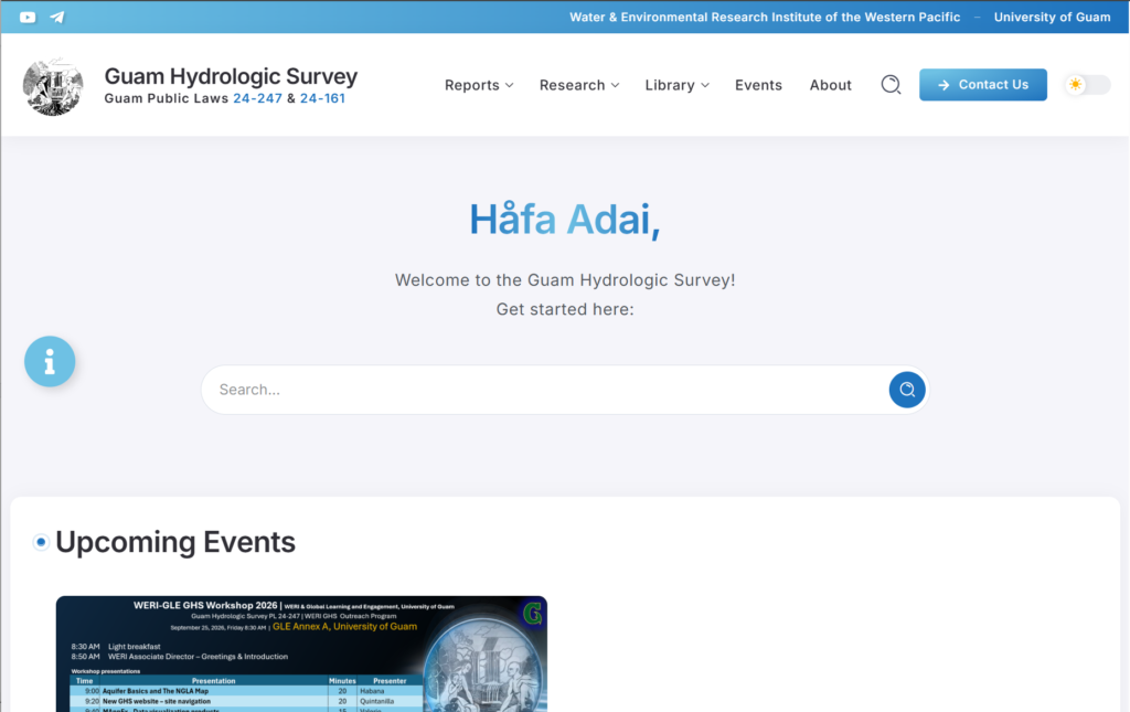
The updated website continues to serve as an important platform for sharing WERI research and developments, including resources presented during WERI GHS Annual Workshops, Guam/CNMI Advisory Council Meetings, conferences, and community outreach events.
Online Data Visualization Products
University Council on Water Resources – National Institute of Water Resources (UCOWR-NIWR 2023)
National Groundwater Association (NGWA 2023)
WERI-FCU Taiwan Research Exchange Event (2024)
American Water Works Association (AWWA) Hawaii Western Pacific Sub Section Conference (2024)
WERI-CWNU G-LAMP South Korea Research Exchange Event (2025)
UOG Center for Island Sustainability (CIS) Conference (2025)
WERI Guam Advisory Council Meeting (2023, 2024, 2026)
WERI-GLE GHS Workshop (2024, 2025, 2026)
From demos showcased in advisory council meetings for the Western Pacific, stakeholders from the CNMI are now sharing nitrates and chloride data to help with data management. In the 2024 AWWA Conference (Hyatt, Tumon), the MAppFx for CNMI BECQ was demonstrated, and Yap expressed interest in having their data converted into a MAppFx product. In 2025, a MAppFx for the FSM was developed to visualize streamflow duration curves for Pohnpei and Kosrae.
In 2023, WERI developed the first two MAppFx products: Northern Guam Lens Aquifer Production Well Nitrates and Ugum Watershed Stream Flow Duration Curves. Following the recent migration of the GHS website, which offers greater opportunity for modern approaches to data management and visualization, WERI continues to expand and further develop the MAppFx Library at:
https://guamhydrologicsurvey.uog.edu/mappfx-library/
The following sections detail the new MAppFx projects and updates are underway for existing MAppFx projects. With the latest data available, the following MAppFx were updated: Northern Guam Lens Aquifer Production Well Nitrates; Southern Guam Watersheds: Streamflow Duration Curves; Chloride and Production; Deep Observation Wells; Production Well Nitrates and Chloride for CNMI; Streamflow Duration Curves for Pohnpei and Kosrae, FSM. The latest addition to the MAppFx Library is the Geo Gallery.
MAppFx
Northern Guam Lens Aquifer Production Well Nitrates

D.K.U. Valerio, M.W. Zapata, and N.C. Habana
WERI Technical Report No. 180 | GHS Online Summary Report | View MAppFx
Web development tools, particularly JavaScript libraries and frameworks, provide extensive resources for building interactive map and graph platforms. With these tools available, the WERI GHS IM team was able to pursue avenues for online hydrologic databases. This led the team to develop a data visualization interface that maps survey points, polygon areas, and polyline boundaries alongside their historic data.
To store the map’s geographic metadata and data for the plot, a JSON (JavaScript Object Notation) file was used. As a result, the first data visualization product in the MAppFx series was produced, titled Northern Guam Lens Aquifer Production Well Nitrates. This MAppFx features an interactive map of Guam’s production wells and nitrate data, based on WERI research by J. Bulaklak and N.C. Habana (2021). Users can interact with the map through layer toggles, drawing tools to highlight select areas for presentation purposes, and information panels that detail statistical analysis summaries and time series plots of available nitrate data.
The project was completed in 2023 and features a functional, highly configurable codebase. This MAppFx has set the model for subsequent MAppFx products. Its source code serves as the base to further expand other MAppFx with additional features, making future products adaptable to project requirements. Statistical summaries and historic plots are updated on the interface when the latest nitrates data becomes available. The GHS Research Team provides the updated and analyzed data for the IM team to convert into a GeoJSON file, which is the basis for the map features and display.
Southern Guam Watersheds - Streamflow Duration Curves

N.C. Habana, L.F. Heitz, and D.K.U. Valerio
Southern Guam’s watersheds and streams may have potential for energy and/or water supply development. Streamflow variability and flow duration analysis are useful information to determine such potential. Flow variability and flow duration curves were quantified directly from gaged sites and ungaged reaches, using inferential techniques (Heitz et al. 2016 and 2017, WTR 154 and 164, respectively). This project expands the MAppFx: Ugum Flow Duration Curves (Habana et al. 2023, WTR 181), into the entire southern Guam (14 watersheds and 19 stream gages).
To obtain proper watershed and stream topology, the technique required modifying the GeoJSON file, expanding its data nesting configuration. All the assessed gaged streams in southern Guam are now available online.
The use of the interactive web map and graph interface was demonstrated at the WERI Guam Hydrologic Survey Workshop in September 2024. More than 40 interagency employees learned about the use and access of MAppFx products in the WERI GHS Workshop 2025. The technical report is underway.
Chloride and Production
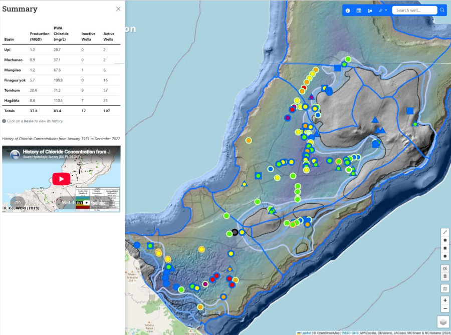
Following the completion of the first MAppFx on Production Well Nitrates in the NGLA (Valerio et al. 2023, WTR 180), the MAppFx for production well chloride was developed to visualize well status on a map and production and chloride trends. Like nitrates, chloride is another important production well constituent that can limit production.
Guam uses about 100 deep vertical wells to extract more than 40 MGD of utility water from the Northern Guam Lens Aquifer (NGLA). The Guam Waterworks Authority (GWA) tests wells for chloride concentration because high levels often result from saltwater intrusion, which can occur when too much water is drawn from the freshwater lens. Elevated chloride also raises salinity, an aesthetic water quality concern. Managing water quality and production therefore includes monitoring changes in chloride in utility water production.
Using the codebase of the MAppFx Production Well Nitrates NGLA, the MAppFx for Chloride and Production expands its interface with an improved double axis graph that features chloride and production rates over time. It also includes a summary of the chloride and production rates per basin in the NGLA. Its web interface opens with a layer version of the Northern Guam Lens Aquifer map (Habana and Jenson 2018) and GWA production wells.
The JSON, JavaScript Object Notation (data form file), for this online application was configured for plotting chloride and production data over time (date). An Excel file is used to organize GWA data, and the Excel program generates the GeoJSON file. This makes ease of managing chloride and production data that can be updated quarterly and serves as a state of the aquifer component.
This data visualization product was coded to provide a summary interface of production weighted average chloride and total production for each aquifer basin in the NGLA. The well points on the interactive map utilize symbology based on the latest data chloride concentration (mg/L or ppm) and production rate (GPM). Side panel widgets are available as well for symbology and summary. The symbology panel is interactive, where users can select to display wells based on concentration and production rate. The summary panel provides the annual production well rate (MGD) and production weighted average chloride concentration for each of the 6 aquifer basins in the NGLA. Selecting each aquifer basin in this panel expands to the last 10 years of annual summaries showing total production and weighted average chloride. Upon selecting a well point on the interactive map, an interactive double axis chart appears showing the historical positive concentration, production, and their respective trend line.
This MAppFx product was presented in September 2024 to the American Water Works Association (AWWA), Hawaii Western Pacific Sub Section, conference. Training for use of the platform was conducted at the annual WERI Guam Hydrologic Survey Workshop to interagency partners. The next task is to try to include the military wells. The technical report is underway.
The GHS Research Team processes the update to the chloride and production database (CPDB) file, and updates for this MAppFx are continually in progress. When the latest data becomes available on this MAppFx, users will see an updated statistical summary on the well’s information pane as well as the chloride and production levels provided by GWA in the time series plot.
Deep Observation Wells
M.W. Zapata, M.C. Snaer, D.K.U. Valerio, S.M. Quintanilla, and N.C. Habana
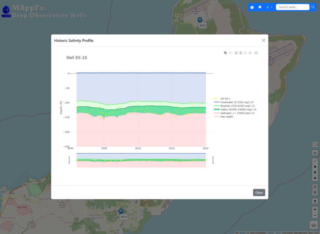
Deep observation wells (DOWs) are phreatic access ports for conducting salinity profiles in the NGLA. A DOW is a vertically positioned tubular structure that extends down a borehole with perforation below the saturated zone, penetrating the freshwater lens, extending into the saltwater zone. This allows for a depth and conductivity analysis that translates into a salinity profile. The salinity profile sampling is done at least twice a year. This operation was conducted as part of the WERI-USGS data collection under the CWMP. Dougher et al. (2019, WTR 168) developed the first historic graphing of salinity profiles for three DOWs in the Tomhom Aquifer, NGLA. The report defines the phreatic zone of freshwater, transition zone, and saltwater. Dougher’s research revealed the capacity and durability of the aquifer that went through a major recharge event from typhoons, followed by a 6-year drought. Recent work by Snaer et al. (2026, WTR 189) expands this analysis across three additional basins, Machanao, Hagåtña, and Pågu, using a total of 8 DOWs. The study found that variation in lens thickness across the DOWs may be influenced by local geology and well location.
In 2024, the GHS IM team developed the historic graph of phreatic zone for the DOWs as a component of the MAppFx web app. On the MAppFx interface, users see 8 DOW historic profiles that began in 2001. In the future, it will include the newly installed DOWs of both GWA and Military. The WERI GHS IM and Research Teams established a workflow that converts the raw Excel data to a JSON file format, MAppFx’s input source and information database. This system is easy to manage and update when new data is received. DOW salinity profiles alone are difficult to analyze and present in such a way that could be well understood. Historic salinity profiles provide a better and valuable insight to determine the status of the aquifer, showing changes in freshwater lens thickness in response to drought and ample recharge. MAppFx makes this easier to visualize and support the management of the island’s major water resource. The overall interface for this MAppFx project is complete, and the data is updated with the help of the GHS Research Team as the latest DOWs data becomes available. These updates will be reflected in the lens profile graph.
Saipan, CNMI - Production Well Nitrates and Chloride
M.W. Zapata, D.K.U. Valerio, S.M. Quintanilla, and N.C. Habana
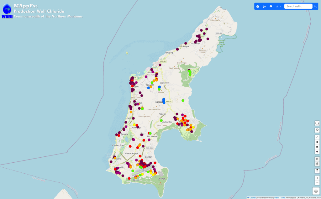
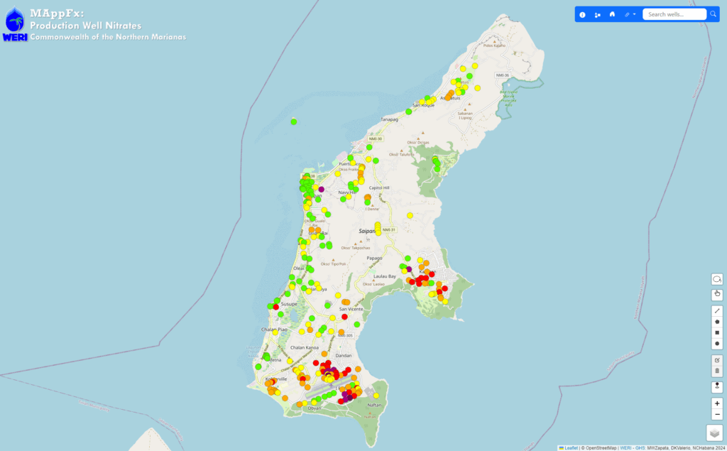
Two MAppFx products were created for Saipan, CNMI using the production well nitrates and chloride data, respectively. The GHS IM Team did not want to create a new website for CNMI, for management purposes, so we placed this MAppFx product on the GHS website for our island neighbor. BECQ has a complex chloride and nitrate database they submit to the GHS IM Team that required developing a sophisticated system to organize their data, an Excel file, and convert it into a JSON file—an input and database reference for the MAppFx interface. The map features an interactive map of Saipan with production wells as the points of survey. Each well is color coded based on a system of values provided by the Saipan BECQ team and can be toggled on/off through the map’s legend and layer control widget. Its graphs display available data for the site that users can also interact with (e.g., selection, zoom in/out).
In essence, it takes on the same codebase as the Chloride and Production MAppFx for Guam, but with the addition of a new selection feature to fulfill the request from BECQ, Saipan. This selection tool allows the user to select multiple wells and view all the graphs in one pane. This view provides a useful summary of the data at a glance, especially when comparing data between selected wells from different regions. To activate this tool, the user would select the lasso widget located towards the bottom right of the screen. This MAppFx was presented at the WERI Advisory Council Meetings and was met with positive reception from the audience.
Updates to the existing nitrate and chloride data for this MAppFx are continuously in progress. When the latest data is received from the CNMI BECQ team, users will see updates to the map symbology, following the most recent value of the water quality parameter collected, as well as updates to the time series plots of sampled wells.
To access the MAppFx products for Saipan, a section for the CNMI was created on the GHS website. From the menu bar, hover over Library and select MAppFx from the submenu. On the MAppFx Library page, scroll down to the CNMI section. A technical report for this project is underway.
Pohnpei and Kosrae, FSM - Stremflow Duration Curves
N.C. Habana, L.F. Heitz, and D.K.U. Valerio
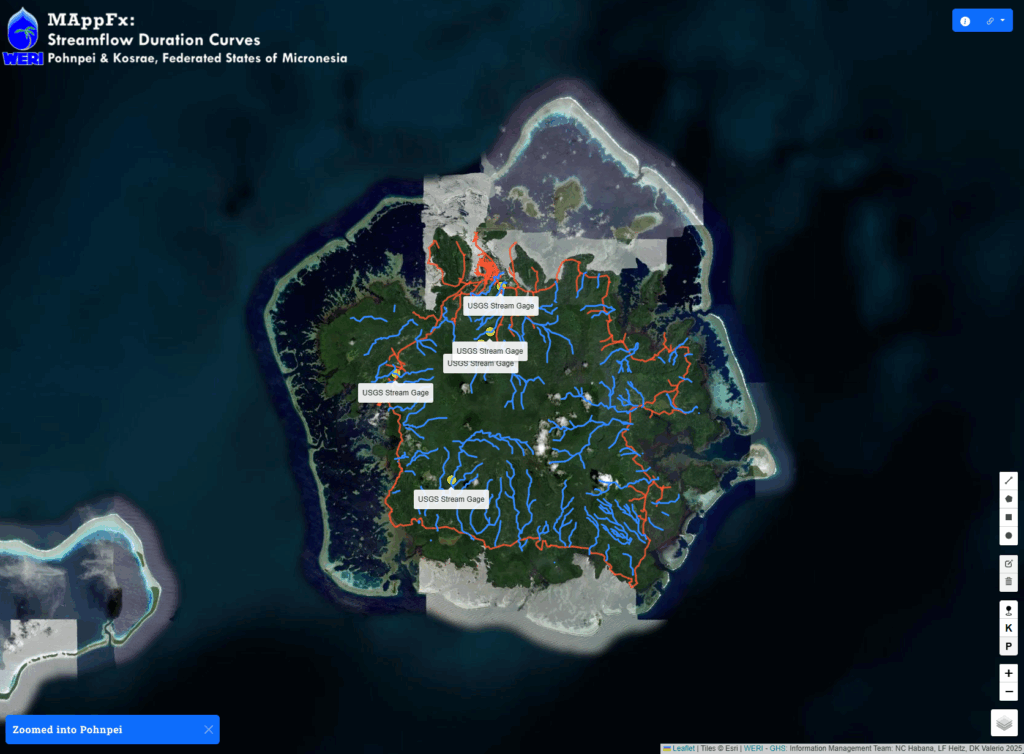
A MAppFx was created for the islands of Pohnpei and Kosrae, FSM, which features streamflow duration curves. After showcasing the Saipan, CNMI MAppFx projects at the 2024 AWWA Conference (Hyatt, Tumon), Yap representatives expressed their interest in converting their data into a MAppFx product. In 2025, the WERI GHS IM team completed this MAppFx for the FSM.
When the page first loads, the map zooms out to have a view of the two islands—Pohnpei and Kosrae. The user can click on one of the islands to get a zoomed in view. Another option to “fly” between the two islands is to use the navigation widget located on the bottom right of the interface. The button labelled as “K” zooms into Kosrae, and the button labelled as “P” zooms into Pohnpei. At its core, this MAppFx maintains the same code as the MAppFx for the Southern Guam Watersheds Streamflow Duration Curves but has been refreshed with reusable code blocks and functions.
To access this MAppFx product, a section for the FSM was created on the GHS website. From the menu bar, hover over Library and select MAppFx from the submenu. On the MAppFx Library page, scroll down to the FSM section. A technical report for this project is underway.
Geology Photo Gallery
D.K.U. Valerio, S.M. Quintanilla, M.C. Snaer, and N.C. Habana
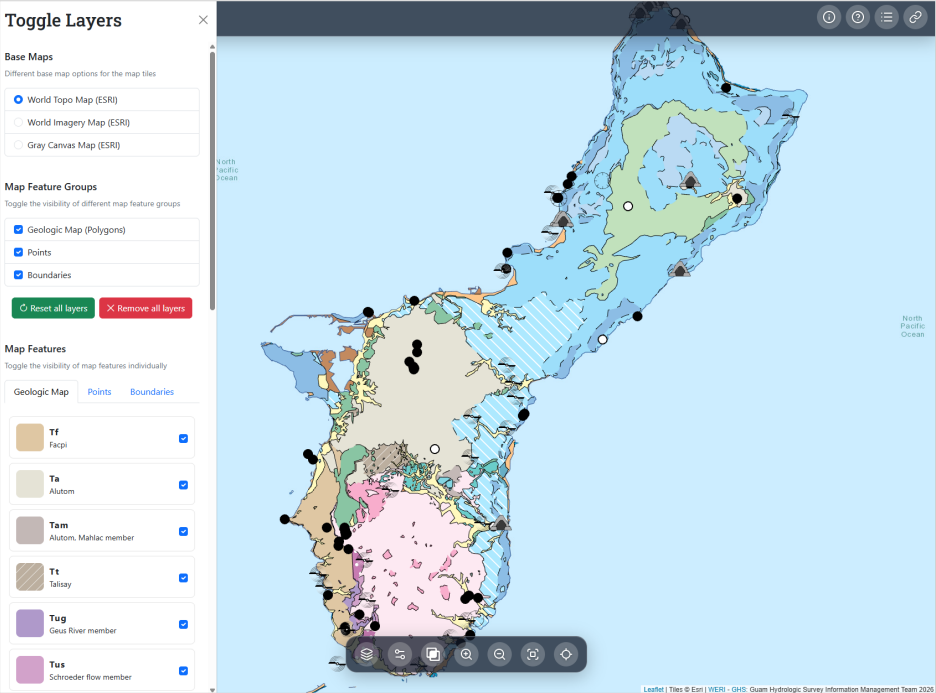
The latest addition to the MAppFx Library is the GeoGallery (GeoGal). Compared to the other web maps in the MAppFx series, this project took on a novel approach with its established database system. Upon the initial page load, GeoGal opens with geologic features based on the Geologic Map and Sections of Guam (Siegrist et al. 2007). These features are represented by polygons while points describe other natural features of Guam. When a user clicks on a map feature, they’re presented with a gallery of photos and videos related to that site. Through this simple interaction, the user can visually explore the island by simply browsing through these photos, which include close-up shots of geologic samples; wide shots of various sceneries, caves, and formations; and aerial shots capturing the full landscape of the select area. Videos were also incorporated to provide a full and immersive experience for the user to peruse through.
In addition to basic map controls (e.g., zoom, locate, and recentering), the GeoGal is packed with new features and interactive tools. A floating dock of map widgets, located towards the bottom of the screen, houses all buttons for the user to interact with the map. The layer toggle allows the user to adjust the map’s appearance by switching the different basemaps or feature layers on/off. This can be done either in groups or individually, providing the user with maximum control to highlight specific features or regions on the map. Users can also adjust the transparency of the geologic features (i.e., polygons), which is useful when positioning features in relation to adjacent locations through street or satellite imagery basemaps. Another highlight is the ability to view cross-sections of the aquifer. When the user selects this button, blue lines that represent the cross-sections will overlay the map. When the user clicks on one of these lines, an image of the selected cross-section appears on screen, where they can zoom in and out of the image. This feature offers a perspective of Guam’s geologic structure and aquifer mechanics in the context of the map. Finally, the GeoGal is also equipped with a set of tutorials on how to use these elements if needed. These video demonstrations can be viewed by clicking on the question mark icon on the navigation bar located on the top right of the screen.
With the availability of this platform, geo-information is more accessible to researchers, students, educators, and agency partners through an easy-to-use online platform. Additionally, it also removes the friction of field excursions when a quick reference or educational tool is needed. A GeoJSON file is used to store the geographic data for the map features; however, this MAppFx utilizes JavaScript API (Application Programming Interface) calls between the backend—the server and data store—and the user interface (frontend) parts of the app that communicate the user’s selection from the map and the metadata for the set of photos to be presented onscreen. The backend part of this MAppFx is organized through a directory system, making it easy to manage future photo collections. Any future updates to the gallery’s database would be a simple drag and drop of photos into their respective folders. To establish and maintain the security and web protocols of the GeoGal, the WERI GHS IM team worked with the UOG Web Development team to setup up secure data endpoints and live deployment of the app. The GeoGal is now accessible through the GHS website’s MAppFx Library or directly through the following link:
This project debuted at the 2026 WERI-GLE GHS Workshop in September 2026, where audience members followed along with the live demonstration. In the future, this platform will expand to include a variety of basemaps pertaining to hydrology, terrain, landcover, and other geographic features. A technical report for this project is underway.
Guam Hydrologic Survey Research
WERI researchers continue to monitor and study Guam’s water resources, using hydrologic data to improve understanding of the island’s hydrologic cycle. This section covers the year’s research activities, starting with the hydrologic cycle, followed by water quantity and quality, hydrology, hydrogeology, and GIS, and concluding with the development and application of groundwater and solute transport models.
Climate and Weather
Guam’s rainfall varies seasonally and is influenced by tropical cyclone activity and El Niño–Southern Oscillation (ENSO). Long-term ENSO, rainfall, and sea-level records provide a basis for examining the wet and dry periods and understanding their effects on Guam’s climate and weather.
Southern Mountain Rain Gage
I. Cruz (NWS) and N.C. Habana
The National Weather Service (NWS) field team, led by Cruz, continues its treks to the Southern Mountain Rain Gage (SMRG), the late Dr. Lander’s rain gage at the top of the Humåtac Watershed. Habana processes and analyzes the rainfall data. In 2023, the year of Typhoon Mawar, the SMRG logged more than 149 in of rainfall, which may be one of the highest annual totals recorded on Guam (see graphs on the following two pages). In 2024, annual rainfall totaled about 100 in. September had the highest monthly total that year at 26.5 in, including two days with rainfall exceeding 4 in, shown by the red bars. In 2025, SMRG logged 100.6 in of rainfall. By April 25, 2026, rainfall for the year had reached 50.9 in.

ENSO RONI, Rainfall, and Sea Level
M.C. Snaer and N.C. Habana
ENSO strength is categorized using a color scheme:
El Niño: Weak [0.5, 1), Moderate [1, 1.5), Strong [1.5, 2), and Super (≥2) are colored in increasing intensities of yellow, orange, and red.
La Niña: Weak [-0.5, -1), Moderate [-1, -1.5), Strong [-1.5, -2), and Super (≤-2) use a progression of light to dark blue and purple.
ENSO neutral is defined by ONI values between -0.5 and 0.5.
Below the RONI plot, three aligned panels illustrate rainfall data from the NWS GIAA rain gage:


- Daily rainfall is depicted using bars colored by intensity, ranging from gray (0–1 inch) to purple (over 10 inches). Notable typhoons, such as Pamela (18.5 inches) and Pongsona (19.7 inches), are labeled next to their corresponding rainfall spikes.
Annual rainfall is shown with a color-graded backdrop, indicating drought conditions (red, <60 inches) through periods of high rainfall (dark blue, >100 inches). Four years recorded near or above 140 inches, while significant droughts occurred in 1973 and 1998, with the latter leading to the CWMP and GHS legislation.
Seasonal rainfall (dry: Jan–Jun; wet: Jul–Dec) is also color-coded using the ROYGB scheme.
The historical record provides a visual reference for understanding the relationship between ENSO and rainfall patterns on Guam.
Rainfall records from 1970 to 2023 show shifts between wet and dry periods. Between 1970 and 1998, dry-season rainfall fell below 10 in five times, a frequency not observed in subsequent decades. The early 2000s were particularly wet, with four years receiving more than 100 in of annual rainfall, including two years exceeding 140 in. This was followed by a drier period from 2005 to 2010, which Lander described as “the big nothing.” During these six years, no daily rainfall total exceeded 5 in, annual totals remained below 100 in, and two years received less than 80 in. Rainfall increased after 2010, with annual totals reaching or exceeding 100 in for eight consecutive years, from 2011 to 2018. Drier conditions returned from 2019 to 2022, when three of the four years received less than 100 in. This pattern reversed in 2023, which brought extreme rainfall that could be compared to that recorded during Typhoon Pamela.
ENSO remained a dominant factor in Guam’s climate. Following the 2023–2024 El Niño, ENSO conditions ranged between ENSO-neutral and La Niña during 2025, when most major typhoons in the western North Pacific formed west of Guam. By May 2026, signs of El Niño onset were evident and NOAA confirmed El Niño conditions in June. El Niño generally favors typhoon formation to the east of Guam, increasing the potential for storms to affect the island. By October 2026, three major typhoons had affected Guam: Sinlaku, Bavi, and Champi.
Water Quantity and Quality
Water quality may limit the quantity of water available for use. In the Northern Guam Lens Aquifer, sustainable groundwater production depends on hydrology and water quality. Through the GHS and CWMP programs, WERI studies these factors to inform efforts to improve production capacity and support further research, including groundwater model development.
Assessment of Water Quality in Guam’s Septic Systems
C. Marzan and Y. Kim
Preliminary UCMR 5 analysis data confirmed that approximately 81% of production well water on Guam contains detectable per- and polyfluoroalkyl substances (PFAS). One underexplored but potentially significant contributor is Guam’s decentralized septic system infrastructure. Approximately 41% of the island’s population relies on individual septic systems, which discharge effluent and suspended solids directly into the vadose zone. Many of these systems are situated directly above the Northern Guam Lens Aquifer (NGLA), the island’s primary drinking water source.
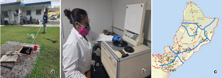
In this study, funded by and conducted in collaboration with the Guam Waterworks Authority (GWA), WERI targeted septic systems across the island to evaluate wastewater quality and analyze PFAS levels. During this fiscal year, the WERI field team visited approximately 140 single-family homes. At roughly 40 locations, access to the septic tanks was blocked due to physical issues with the tank covers, including stuck lids, broken handles, or covers sealed shut with cement. At each of the 100 accessible locations, the team collected two separate 500 mL HDPE bottles: one containing wastewater and the other containing wastewater with sludge. Sample retrieval was executed using dedicated field equipment, including a 1.1 m to 3.0 m stainless steel telescopic water sampler dipper, a 600 mL pendulum beaker sampler ladle, and a 3.0 m sampling pole. Currently, the samples have been shipped to the University of Rhode Island for PFAS analysis.
Hydrology, Hydrogeology, and GIS
WERI combines field observations, long-term hydrologic records, and GIS to study Guam’s surface water and groundwater resources. Current projects include hydrologic maps, watershed and water quality monitoring, freshwater lens analysis, groundwater vulnerability assessment, and land cover change analysis. These studies improve understanding of Guam’s hydrology and their response to environmental conditions and human activities, supporting water resource management, land-use planning, and groundwater protection.
Hydrologic Map of Guam Watersheds

N.C. Habana, D.K.U. Valerio, M.C. Snaer, and L.F. Heitz
Technical Report 190 | Web MApp
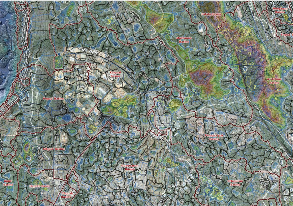
The strategic protection and development of southern Guam’s water resources requires a comprehensive, highly detailed, and well-organized surface hydrology map. Southern Guam’s hydrology involves watersheds of rivers and stream valleys, and karst that yield springs. Currently, hydrologic maps of southern Guam are limited to GIS map analysis distributed as single shapefile or raster-file pieces, such as watershed and rivers. The maps are often crude, limited to resolution or refined scale, found in technical reports or a workstation GIS. Interagency sharing of useful maps is also limited. This project utilized the latest and best available, 1 m cell resolution, digital elevation map and GIS hydrologic spatial analyses techniques, producing a very useful and comprehensive hydrologic map of southern Guam that overlays hydrologic boundaries, surface water, and terrain analysis. The hydrologic map of southern Guam is available online as a pdf file where stakeholders and water resource managers to use for determining strategic development, planning, and watershed protection.
Hydrologic Map of Guam (plateau basins and watersheds)
N.C. Habana, M.C. Snaer, D.K.U. Valerio, and L.F. Heitz
The strategic protection and sustainable management of Guam’s natural resources necessitate advanced and fine detail surface hydrologic maps to inform decisionmaking. All previous hydrologic maps of Guam are outdated, crude, and lacks useful information to support planning and development with strategic and protective intention as development over the water sources increase. The availability of high-resolution digital elevation maps will yield the production of a very refined surface hydrology and terrain analysis map. This research has developed a comprehensive surface hydrology map of Guam by integrating high-resolution terrain data and optimized spatial analysis techniques. Leveraging NOAA’s 2020 digital elevation model (DEM) and recent advancements in southern Guam’s surface hydrology modeling, this study unifies the hydrologic systems of Guam’s two distinct physiographic regions—the northern carbonate plateau and the southern volcanic watersheds—into a cohesive, island-wide framework. Key objectives included refining automated hydrologic algorithms to enhance processing efficiency, updated northern Guam’s hydrologic delineations. The integration of these regions will resolve longstanding gaps in delineations of watersheds, flow-path, surface depressions, critical for resource management, securities, and resilience planning. Preliminary results have already garnered significant interest from stakeholders, including the U.S. Environmental Protection Agency (USEPA) and U.S. Army Corps of Engineers (USACE), who recognize the map’s utility in guiding infrastructure development, pollution mitigation, and disaster preparedness. The deliverable—a high-resolution pdf map and accompanying technical report—will provide actionable insights for interagency collaboration, public education, and evidence-based policymaking. Also, for GIS users, the layers package will also be available on the GHS website for download. By applying cutting-edge geospatial technologies with localized hydrologic expertise, this project established a foundational resource towards safeguarding Guam’s environment and water resources amid environmental and anthropogenic stresses.
Identification of Hydrological Characteristics of Ugum Watersheds
M.H. Yeo
The Ugum watershed, located in southern Guam, encompasses approximately 19 km² and extends from the Mount Bolanos area to the confluence of the Ugum and Talofofo Rivers, approximately 0.8 km inland from the coast. The watershed is characterized by steep upper slopes and is underlain predominantly by deeply weathered volcanic-derived sedimentary formations. The Ugum River is considered as an important surface-water source for public drinking-water supply and is diverted for treatment prior to distribution. Previous assessments have identified vegetation loss, grass fires, and off-road vehicle disturbance as potential factors contributing to soil erosion within the watershed. These watershed characteristics provide relevant background for interpreting sediment-monitoring results; however, they do not, by themselves, establish the specific causes of elevated sediment concentrations observed in individual samples.
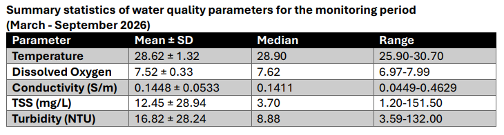
A table below summarizes water-quality conditions observed during the March–September 2026 monitoring period. Temperature and dissolved oxygen were relatively stable, with mean values of 28.62 ± 1.32°C and 7.52 ± 0.33 mg/L, respectively. Conductivity showed greater variation, ranging from 0.0449 to 0.4629 S/m, which suggests changes in dissolved-ion concentrations among sampling conditions. TSS and turbidity exhibited the greatest variability, with mean values substantially higher than their medians and wide observed ranges (1.20–151.50 mg/L for TSS and 3.59–132.00 NTU for turbidity). The differences between the means and medians indicate that most observations were relatively low, while a smaller number of high-value events increased the overall averages.
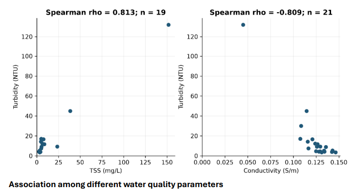
The analysis showed a strong positive correlation between turbidity and TSS (Spearman’s ρ = 0.813) and a strong negative correlation between turbidity and conductivity (ρ = −0.809). This pattern may be consistent with periods of increased runoff and dilution during storm events, although the available data does not establish a direct cause. Because the dataset is limited and includes several high-value observations that strongly influence the overall relationships, these results should be interpreted cautiously and supported by additional event-based monitoring.
Land Cover and Land Cover Change in NGLA
N. Mathews and Y. Wen
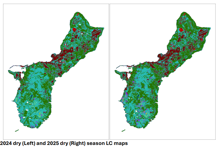
The Northern Guam Lens Aquifer (NGLA) supplies approximately 90% of Guam’s potable water, with the Finegayan Basin providing roughly 15% of total production despite only 7% of the aquifer surface area (Bendixson, 2014; Ko et al., 2022). However, recent geospatial analyses indicate that 62.5% of production wells within the basin exhibit a significant increasing trend in chloride concentrations (Ko et al., 2022; Ko & Wen, 2025). In recent years, land cover within and surrounding the basin has seen significant change and development, notably the construction of Marine Corps Base Camp Blaz. Rapid transformation and urbanization introduce impervious surfaces that alter natural recharge dynamics in permeable karst limestone terrain such as the NGLA (Shuster et al., 2005; Simpson et al., 2022). This project addresses a critical knowledge gap by establishing a seasonally calibrated remote sensing workflow to quantify spatiotemporal land cover change (LCC) from 2000 to present and evaluating its statistical correlation with wellhead chloride levels. To counteract Guam’s persistent tropical cloud cover and high seasonal spectral variability between the wet (July-December) and dry (January-June) seasons, multi-temporal seasonal mosaics are constructed from USGS Landsat 7, 8, and 9 imagery. A two-tiered cloud removal method using Quality Assurance (QA) pixel masking and manual vector clipping of remaining cloud halos and thin shadows is utilized for removal of clouds and shadows. Supervised classification is executed using Support Vector Machine (SVM) algorithm in ArcGIS Pro, utilizing season-specific base training sets for stable land cover types alongside supplemental samples fine-tuned for dynamic classes such as badlands, burn scars, and developing urban areas. Analyses indicate that an average of 85.38% overall accuracy and 0.83 Kappa are achieved. This research provides a transferable methodology for cloud-persistent island environments and delivers critical data to support data-driven
groundwater management across the NGLA in Guam.
Establishing a GIS-based Model for Updating Groundwater Protection Zones in Guam
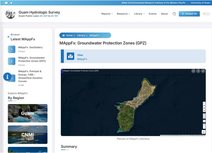
Y. Wen and R. Uludong
The groundwater from the karst limestone aquifer in northern Guam provides local residents, the military, and tourists with approximately 90% of their daily water needs. Though the availability of water resources in Guam is adequate for the current population, the projected increasing population caused by the military buildup activities, foreign labors, and recovering tourism industry will impose pressure on the water resources in Guam. What’s more, the high porosity and rapid recharge characteristics of the Northern Guam Lens Aquifer (NGLA) make it vulnerable to contamination from urban runoff, chemical spills, effluents from septic tanks or septic tank leaking, anthropogenic activities and sewage overflows.
Since groundwater in the Northern Guam Lens Aquifer supplies local residents, DoD, and tourists with about 90% daily water use, it’s crucial to update the groundwater protection zones (GPZs) map and make sure that water resources can be well managed so that the daily life of the people of the island will not be affected. The main purpose of the project aimed to establish a GIS-based model suitable to the karst island like Guam for updating GPZs in northern Guam, particularly the NGLA. Most of the island’s anthropogenic activities, infrastructures, waste and wastewater transmission are situated atop of the aquifer. There are ongoing and continuation of anthropogenic activities (developments) that are drawing concerns about aquifer vulnerability. With advanced geospatial technologies, it is possible to evaluate the vulnerability of the GPZ so that the sustainability of the island’s water resources and ecosystem can be addressed. The project focuses on a standardized system for evaluating groundwater pollution potential using hydrogeologic settings, i.e. the DRASTIC model for calculation of weights and ratings for its parameters. The parameters of DRASTIC include Depth to water table, net Recharge, Aquifer media, Soil media, Topography (Slope), Impact to the vadose zone, and hydraulic Conductivity need to be collected and processed. The parameters are used to quantify the weights and ratings for the model so that the DRASTIC index can be calculated to evaluate the pollution potential for groundwater resources. In order to figure out the DRASTIC index, the data of water table, rainfall, geologic features, soil types, digital elevation model data, the media in vadose zone to determine the impact to the vadose zone, and hydraulic conductivity. The next fiscal year’s work will continue quantification of the parameters of the model and implement the model for evaluation of the pollution potential vulnerability index.
Deep Observation Wells
M.C. Snaer, N.C. Habana, Y. Kim, and L. Aquino
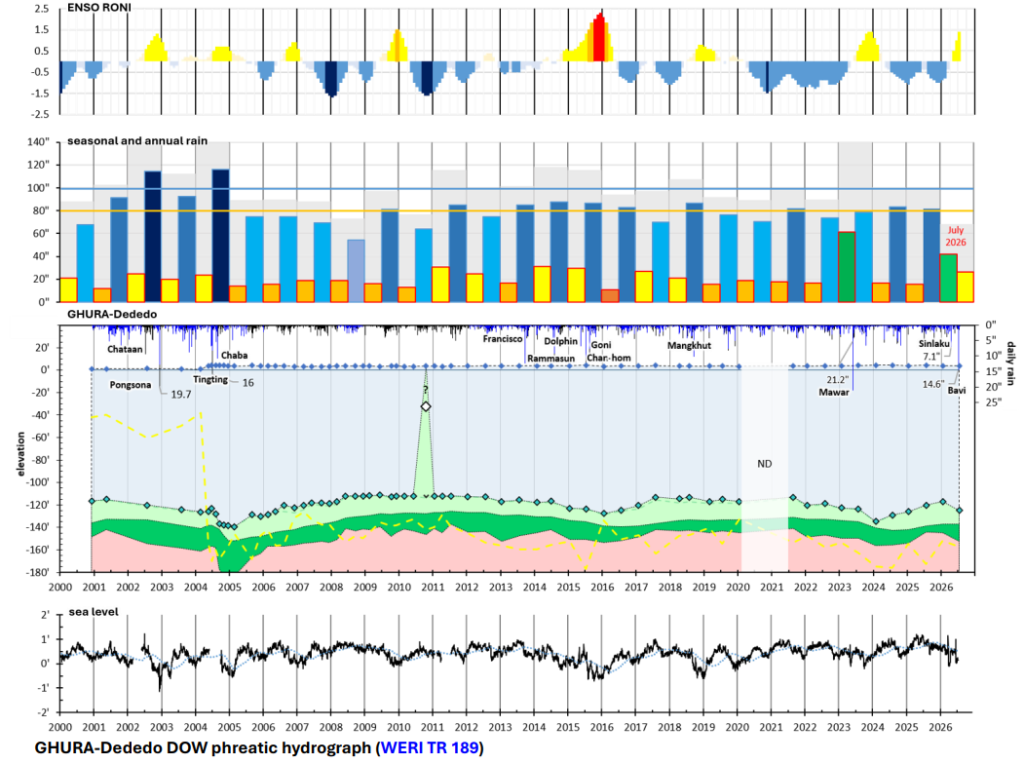
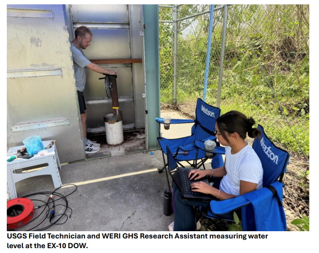
Deep Observation Wells (DOWs) are used to obtain detailed salinity profiles and water levels in the phreatic zone of the Northern Guam Lens Aquifer (NGLA), which contains a freshwater lens that supplies about 90% of Guam’s utility water. Beneath the freshwater lens, a transition zone grades with depth from brackish to saline and ultimately to saltwater. Eight DOWs with long-term records and seven recently installed DOWs are located across Northern Guam and extend into the saltwater portion of the phreatic zone. Conductivity, temperature, and depth (CTD) probes are lowered into the DOWs semi-annually to collect water levels, freshwater lens thickness, transition zone fluctuations, and saltwater interface position.
These long-term DOW records were analyzed as part of Mary Clare Snaer’s master’s thesis research in the Environmental Science Program at the University of Guam (UOG). Supported by WERI and the GHS program, Ms. Snaer successfully defended her master’s thesis in April 2026 (includes video of defense). Her phreatic hydrograph analyses integrated 24 years of conductivity (salinity) data from nine DOWs with rainfall, sea level, and the Oceanic Niño Index (ONI) to assess freshwater lens response to hydrologic factors and El Niño Southern Oscillation (ENSO). At the GHURA-Dededo DOW, for example, lens thickness fluctuates with periods of drought and recharge, including typhoons such as Pongsona (2002), Dolphin (2015), Mangkhut (2018), and Mawar (2023), and more recently Bavi and Sinlaku (2026). Her research is also published as WERI Technical Report 189.
Ms. Snaer also presented her research and represented WERI and UOG at numerous conferences, both on Guam and nationally. These included the 2024 AWRA/UCOWR/NIWR Joint Water Resources Conference (St. Louis, MO), 2024 NGWA Groundwater Week (Las Vegas, NV), and the 2025 and 2026 UCOWR/NIWR Annual Water Resources Conferences (Minneapolis, MN and San Antonio, TX). On Guam, she presented at the annual WERI-GLE GHS Workshops (2024, 2025, and 2026) and at the 2024 WERI Guam Advisory Council meeting. She received the Farvolden Scholarship at 2024 NGWA Groundwater Week, as well as two NIWR Regional Student Travel Awards for the Oceania and Islands Region to attend the 2024 AWRA/UCOWR/NIWR Joint Water Resources Conference and the 2025 UCOWR/NIWR Annual Water Resources Conference. WERI UOG and the GHS Program proudly graduate an outstanding environmental scientist.

Groundwater Modeling
The studies discussed above are key components in developing a useful model of the island’s sole source aquifer. The research provides important hydrologic and statistical information that is key to building a reliable model. Groundwater models can run an acceptable representation on a computer, simulating and testing scenarios for optimum development. Although hydrologic models have limitations, they provide insight into aquifer capacity and vulnerability and may help with determining sustainable development and water resources management strategies, including appropriate regulations/laws to protect the aquifer.
Nitrate-N Solute Transport of the Tomhom Aquifer Basin
A. Bautista, J.A. Caasi, M.C. Snaer, T. Wood, and N.C, Habana
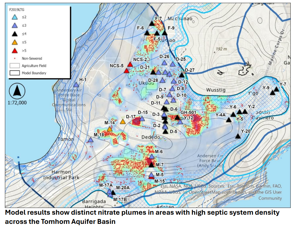
This project builds upon the Swamp Road pilot model by applying a similar MODFLOW-USG solute transport modeling framework in GMS to the Tomhom Aquifer Basin, the most productive aquifer basin within the NGLA. The completed study was published as WERI Technical Report 191 and evaluated three modeling scenarios that incorporated groundwater pumping conditions and nitrate loading to assess nitrate migration toward production wells. One scenario included existing septic tank systems, where nitrate hotspots and plume development were observed. These findings highlight the importance of proper wastewater management in protecting the quality of Guam’s primary aquifer. This study was presented at the 2025 and 2026 WERI-GLE Guam Hydrologic Survey (GHS) Workshops.
A. Bautista, J.A. Caasi, M.C. Snaer, T. Wood, and N.C, Habana
Technical Report 191
This project builds upon the Swamp Road pilot model by applying a similar MODFLOW-USG solute transport modeling framework in GMS to the Tomhom Aquifer Basin, the most productive aquifer basin within the NGLA. The completed study was published as WERI Technical Report 191 and evaluated three modeling scenarios that incorporated groundwater pumping conditions and nitrate loading to assess nitrate migration toward production wells. One scenario included existing septic tank systems, where nitrate hotspots and plume development were observed. These findings highlight the importance of proper wastewater management in protecting the quality of Guam’s primary aquifer. This study was presented at the 2025 and 2026 WERI-GLE Guam Hydrologic Survey (GHS) Workshops.
Nitrate-N Solute Transport of the Swamp Road Area
A. Bautista, J.A. Caasi, T. Wood, and N.C. Habana
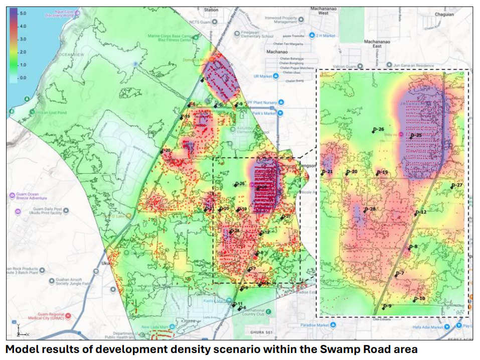
Continued urban growth, aging residential areas, and wastewater discharge from septic systems and leaking/overflowing sewer mains have posed threats to groundwater quality. Nitrate analyses of production wells show rising nitrate-N concentrations over time (The Guam Daily Post, 2020). A 3-D nitrate-N solute transport model was developed for the Swamp Road area in Dededo, with results presented in WERI Technical Report 187. This model incorporates the flow model component from the SEAWAT phreatic model of the Tomhom Aquifer Basin and includes nitrate-N sources from wastewater discharge (non-sewered homes, septic tanks), natural vegetation (legumes, “tangan-tangan” – leucaena leucocephala) and agricultural activities. Additionally, the model simulates a planned housing development in the area using proposed residential parcels consisting of one-eighth acre and less-than-half-acre lots, all using septic tanks. The model results revealed the extent of contaminant plumes near production wells, providing information that may help guide future development and groundwater management decisions. The study has been presented to island agencies and at several professional venues, including 2023 Guam Advisory Council Meeting, 2023 NGWA conference, and the 2024 AWRA, UCOWR, and NIWR Joint Water Resources Conference. The Swamp Road model serves as a pilot study for continued research on groundwater contaminant transport across Guam, with opportunities for further refinement.
Finagua’yok Aquifer Model, well relocation study
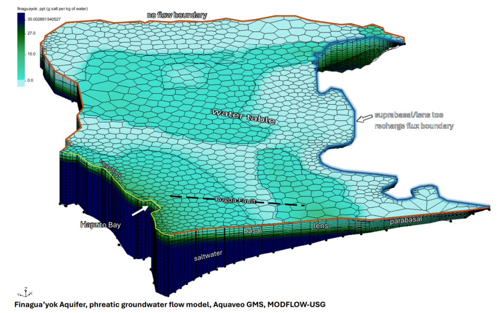
J.A. Caasi, M.C. Snaer, A.L. Bautista, T. Wood, and N.C. Habana
Some of Guam’s production wells are in locations within the aquifer that limit utility water production to low pump rates, usually due to saltwater intrusion. This project examines relocating underperforming wells inland to the parabasal zone, a more productive “sweet spot.” In this zone, the freshwater lens portion is on basement rock rather than saltwater, making wells less susceptible to saltwater updraw. Early studies of production and chloride documented well production history showing that parabasal wells were less susceptible to saltwater updraw (McDonald and Jenson 2003). Aquaveo’s Groundwater Modeling Systems (GMS), a computer groundwater model application, is used to construct the Finagua’yok Aquifer phreatic section, and using MODFLOW-USG module to run scenarios that may provide insight to the performance of wells transferred to the parabasal zone.
The groundwater modeling team continues to build the Finagua’yok groundwater model. GIS spatial analysis and hydrologic tools were applied to determine the model’s hydrologic boundaries. Flow direction analysis of the water table in the Finagua’yok aquifer was used to determine the flow line boundary. Flow direction analysis was also applied to the basement to connect the suprabasal/lens-toe recharge flux. Flow accumulation was used to determine recharge flux at the lens toe. The model was run for 20 years using an average recharge rate applied to a saltwater saturated phreatic zone. The lens formed and thickened until changes were no longer observed, indicating steady state. The next step is to bring in production and observation well information to match the model to the data.
Next, low producing wells (<100 gpm) will be selected and relocated to the parabasal zone within select property parcels. The preferred land parcel is on government property with nearby utilities and access. The other option is on private property. This project is ongoing and developing. A figure of the no pumping phreatic freshwater lens of the Finagua’yok aquifer is shown in the next page. Another significant geologic feature in the Finagua’yok aquifer that would be interesting to include is the Pugua Fault, which would help visualize effects to the lens due to seawater intrusion.
Guam Hydrologic Survey Outreach - Virtual Tour, Workshops, Conferences, Symposiums, and Meetings
Workshop, and Educational Outreach
The following are WERI GHS outreach stages where WERI shared their work through tours, workshops, and educational outreach to our public-school students. The following are links to the events/news and full stories on the WERI website:
The WERI-GLE GHS Workshop, along with the Guam Advisory Council Meeting, is one of the GHS Outreach Program’s most sought-after outreach events that island stakeholders in the government, military, and private sectors look forward to attending. This year’s workshop was attended by more than 10 important stakeholder agencies on the island.
Workshop Agency Attendees:
Bureau of Statistics and Plans, Guam Coastal Management Program
Guam Department of Education: JFK High School and Guam Community College
Guam Department of Agriculture
Guam Environmental Protection Agency
Guam Waterworks Authority
Joint Region Marianas (USAF 36 CES, NAVFAC MAR)
National Weather Service, Weather Forecast Office
University of Guam: CLASS/DEAL, CNAS, RCUOG, SENG, WERI
US Army Corps of Engineers
Private sector
Workshop presentations were also submitted and are available on the GHS website:
2026 GHS Workshop Presentations
Workshop Presentation | Presenter:
Aquifer Basics | Habana
New GHS website – site navigation | Quintanilla
MAppFx – Data visualization products | Valerio
MAppFx – GeoGal 2026 New Product | Valerio
NGLA DOWs, Technical Report (TR) 189 | Snaer
Nitrate-N MODFLOW-USG – Tomhom Aquifer, TR 191 | Bautista
A New Landcover Map | Mathews
Hydrologic Map of Guam Watersheds, TR 190 | Habana
GCMP – Geodatabase | Pangelinan
NWS – State of the Climate, ENSO | Aydlett
GEPA – Dieldrin and PFAS | DeGrange
GWA – Production Well GAC Filters | Verango and Santos
SOTAR 2026 | Bautista
WERI WQ Laboratory Services, and the Environmental Science Graduate Studies Program | Habana
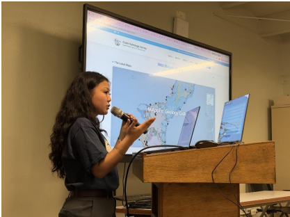
Conference/Symposium/Meeting Presentations
During 2025 and FY 2026, the following were outreach events where GHS projects and products were presented at conferences and stakeholder meetings. The following are links to the events/news on the WERI website:
Local News
WERI took an active role in public engagement, and WERI faculty provided numerous presentations and disseminated information to address community issues and concerns related to the contaminants. The contamination received coverage in news outlets, including the Guam Daily Post and the Guam Pacific Daily News, prompting WERI to provide expert commentary and clarification. WERI must be given all the data about these contaminants to provide better analysis and information. The following are links to news/views about utility water quality:
2025–2026 Dieldrin:
The Cool Down (Aug 28) Guam delayed warning after tests found banned…
WERI News (Sep 25) Addressing tap water safety concerns on Guam
WERI News (Dec 19) WERI assists USEPA and GEPA investigate dieldrin sources
GWA Official information source – Dieldrin timeline | Official Press Release collection
Guam PDN – Dieldrin news/views collection
Guam Daily Post – Water quality (dieldrin and PFAS) news/views collection
2025–2026 PFAS News/views:
Guam PDN: (July 31, 2025) CCU OKs exploratory… | (Aug 27, 2025) Criticism over PFAS… | (May 20, 2026) USEPA grants…
Guam Daily Post: (Sep 21) 1,112 Yigo GWA customers… | (Sep 23) “I’m not going to drink tap…”… | (Oct 2) Emergency declared… | (Oct 21, 2026) New maximum level… | (Oct 22, 2026) How to protect…
Comprehensive Water Monitoring Program Activities
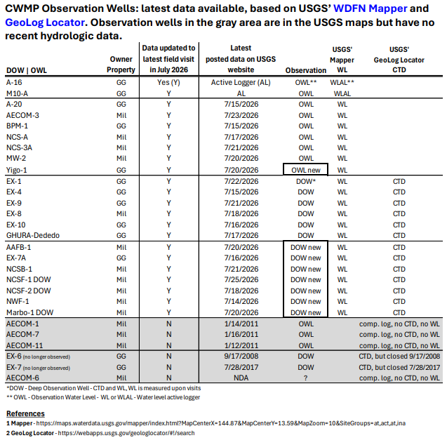
USGS-PIWSC continues hydrologic data collection under the CWMP. New DOWs have been constructed to improve phreatic modeling, historic profile assessments, and understanding of freshwater availability. However, the addition of new wells increases gaging and sampling, requiring additional operational and logistical support. In accordance with Public Law 24-247, the Government of Guam funds 50% of the CWMP cost share with USGS-PIWSC. This fiscal year, USGS-PIWSC completed three field visits to Guam. The most recently approved and published data are current through July 2026.
USGS-WERI Observation Well Data Collection
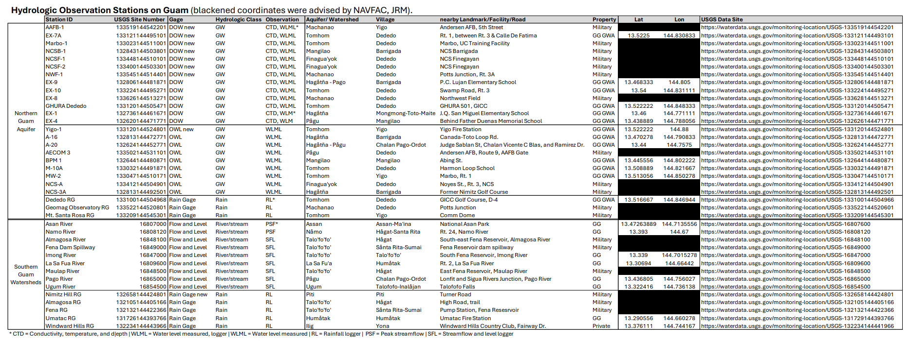
CWMP activities continued throughout FY 2026. The table below summarizes groundwater and surface water data collection activities conducted by USGS-PIWSC at each hydrologic station.
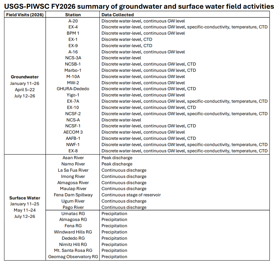
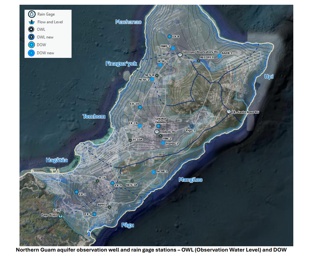
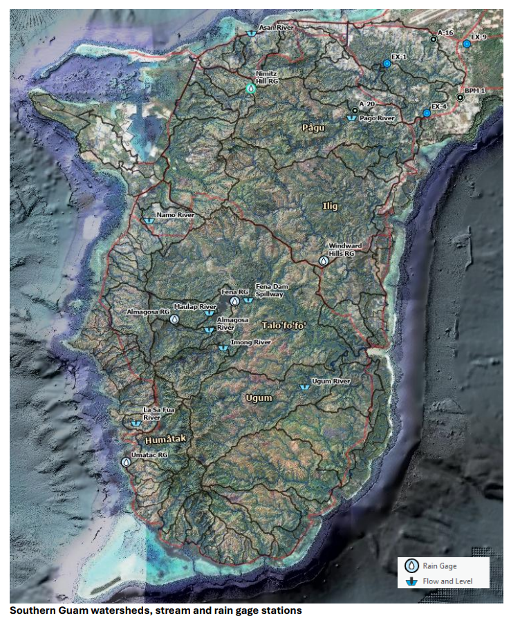
USGS operates 39 hydrologic gaging sites—22 within the aquifer and 17 within watersheds. Conductivity, temperature, and depth (CTD) measurements at the DOWs are collected semi-annually, typically in January and July. The following tables identify these stations and are accompanied by maps showing their locations within the aquifer and watersheds. A link to the USGS Water Data for the Nation (WDFN) online Mapper and GeoLog Locator are also provided (see following four pages).
GHS-funded WERI Research Assistant and UOG Environmental Science program graduate Mary Clare Snaer joined the USGS field team for most DOW site visits, assisting with hydrologic data collection. The long-term CTD records collected through the CWMP also supported Snaer’s master’s research, a hydrologic analysis of the phreatic zone (see Deep Observation Wells section above).
Pertinent Hydrologic Data
The CWMP is public law that allows access to pertinent hydrologic data from interagency partners. GWA provides WERI monthly chloride and production data, which has been instrumental in developing MAppFx data visualization products and advancing research on groundwater flow, salinity, and nitrate transport. GEPA shares water quality data upon request. To improve studies and public information about our water source, data-sharing is imperative. The GHS Program takes hydrologic information to conduct scientific research analysis and reports. Acquiring even sensitive hydrologic information is very important, so agencies can improve transparency, rebuild public trust, and ultimately strengthen Guam’s water resource protection strategies.
State of the Aquifer 2026
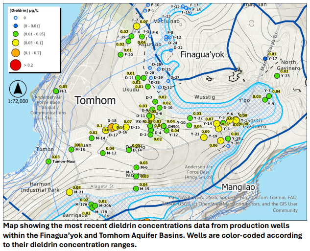
A. Bautista, M.C. Snaer, and N.C. Habana
The 2026 State of the Aquifer Report provides updated information on the Northern Guam Lens Aquifer (NGLA) and is now available on the Guam Hydrologic Survey website. The report covers key topics related to groundwater quality, quantity, and hydrologic conditions within the NGLA. The water quality section includes current maps of dieldrin and PFAS concentrations in production wells and identifies wells with increasing nitrate-N trends. The following section presents climate and rainfall conditions from 2000 through 2026. Next, groundwater production and chloride concentrations from GWA and military wells are summarized from 2020 through June 2026. Lastly, the report concludes with phreatic profiles from six recently installed Deep Observation Wells (DOWs) from 2023 to July 2026. The report was recently presented at the 2026 WERI-GLE Guam Hydrologic Survey Workshop.