
Maps & Posters Library
To access the file, please click on the blue title.
Geologic, Topographic Soils
| Name | Author | Year Published | Agency | Department |
|---|---|---|---|
| Siegrist, Reagan, Randall and Jenson 2008 - Geologic Map Sections, Guam Mariana Islands (scan) | Siegrist, Reagan, Randall and Jenson | 2008 | Water & Environmental Research Institute of the Western Pacific, University of Guam |
| Siegrist et al. 2007 - Geologic Map of Agat Quadrangle, Guam | Siegrist et al. | 2007 | Water & Environmental Research Institute of the Western Pacific, University of Guam |
| Siegrist, Reagan, Randall and Jenson 2008 - Geologic Map Sections, Guam Mariana Islands (scan) | Siegrist et al. | 2007 | Water & Environmental Research Institute of the Western Pacific, University of Guam |
| Siegrist et al. 2007 – Geologic Map of Dededo Quadrangle, Guam | Siegrist et al. | 2007 | Water & Environmental Research Institute of the Western Pacific, University of Guam |
| Siegrist et al. 2007 – Geologic Map of Hagåtña Quadrangle, Guam | Siegrist et al. | 2007 | Water & Environmental Research Institute of the Western Pacific, University of Guam |
| Siegrist et al. 2007 – Geologic Map of Inarajan Quadrangle, Guam | Siegrist et al. | 2007 | Water & Environmental Research Institute of the Western Pacific, University of Guam |
| Siegrist et al. 2007 – Geologic Map of Merizo Quadrangle, Guam | Siegrist et al. | 2007 | Water & Environmental Research Institute of the Western Pacific, University of Guam |
| *Siegrist et al. 2007 – Geologic Map of Pati Point Quadrangle, Guam | Siegrist et al. | 2007 | Water & Environmental Research Institute of the Western Pacific, University of Guam |
| *Siegrist et al. 2007 – Geologic Map of Ritidian Point Quadrangle, Guam | Siegrist et al. | 2007 | Water & Environmental Research Institute of the Western Pacific, University of Guam |
| *Siegrist et al. 2007 – Geologic Map of Talofofo Quadrangle, Guam | Siegrist et al. | 2007 | Water & Environmental Research Institute of the Western Pacific, University of Guam |
| Siegrist et al. 2008 – Generalized Geology of Guam, Mariana Islands (Stratigraph Map) | Siegrist et al. | 2007 | Water & Environmental Research Institute of the Western Pacific, University of Guam |
| Siegrist et al. 2008 – Composite Stratigraphic Sections (use with Stratigraph Map) | Siegrist et al. | 2008 | Water & Environmental Research Institute of the Western Pacific, University of Guam |
| Siegrist et al. 2008 – Composite Stratigraphic Sections (use with Stratigraph Map) | Siegrist et al. | 2008 | Water & Environmental Research Institute of the Western Pacific, University of Guam |
| Tracey et al. 1964 – Geologic Map Sections Guam Mariana Islands, Professional Paper 403 | Tracey et al. | 1964 | US Department of Interior, Geologic Survey, and NOS/NOAA, in cooperation with GovGuam |
| Tracey et al. 1964 – Sample Locality Map of Guam, Mariana Islands, Professional Paper 403-A Plate 2 | Tracey et al. | 1964 | US Department of Interior, Geologic Survey, and NOS/NOAA, in cooperation with GovGuam |
| 1968 – Agat, Guam, Quadrangle | 1968 | US Department of Interior, Geologic Survey, and NOS/NOAA, in cooperation with GovGuam | |
| 1968 – Apra Harbor, Guam, Quadrangle | 1968 | US Department of Interior, Geologic Survey, and NOS/NOAA, in cooperation with GovGuam | |
| 1968 – Dededo, Guam, Quadrangle | 1968 | US Department of Interior, Geologic Survey, and NOS/NOAA, in cooperation with GovGuam | |
| 1968 – Inarajan, Guam, Quadrangle | 1968 | US Department of Interior, Geologic Survey, and NOS/NOAA, in cooperation with GovGuam | |
| 1968 – Inarajan, Guam, Quadrangle, Mylar | 1968 | US Department of Interior, Geologic Survey, and NOS/NOAA, in cooperation with GovGuam | |
| 1968 – Merizo, Guam, Quadrangle | 1968 | US Department of Interior, Geologic Survey, and NOS/NOAA, in cooperation with GovGuam | |
| 1968 – Merizo, Guam, Quadrangle, Mylar | 1968 | US Department of Interior, Geologic Survey, and NOS/NOAA, in cooperation with GovGuam | |
| 1975 (68) – Agana, Guam, Quadrangle | 1975 | US Department of Interior, Geologic Survey, and NOS/NOAA, in cooperation with GovGuam | |
| 1975 (68) – Agana, Guam, Quadrangle, Mylar | 1975 | US Department of Interior, Geologic Survey, and NOS/NOAA, in cooperation with GovGuam | |
| 1975 (68) – Agat, Guam, Quadrangle, Mylar | 1975 | US Department of Interior, Geologic Survey, and NOS/NOAA, in cooperation with GovGuam | |
| 1975 (68) – Apra Harbor, Guam, Quadrangle, Mylar | 1975 | US Department of Interior, Geologic Survey, and NOS/NOAA, in cooperation with GovGuam | |
| 1975 (68) – Pati Pont, Guam, Quadrangle | 1975 | US Department of Interior, Geologic Survey, and NOS/NOAA, in cooperation with GovGuam | |
| 1975 (68) – Pati Pont, Guam, Quadrangle, Mylar | 1975 | US Department of Interior, Geologic Survey, and NOS/NOAA, in cooperation with GovGuam | |
| 1975 (68) – Ritidian Point, Guam, Quadrangle | 1975 | US Department of Interior, Geologic Survey, and NOS/NOAA, in cooperation with GovGuam | |
| 1975 (68) – Ritidian Point, Guam, Quadrangle, Mylar | 1975 | US Department of Interior, Geologic Survey, and NOS/NOAA, in cooperation with GovGuam | |
| 1975 (68) – Talofofo, Guam, Quadrangle, Mylar | US Department of Interior, Geologic Survey, and NOS/NOAA, in cooperation with GovGuam | ||
| USGS Topographic Maps | USGS | ||
| USGS Geologic Maps | USGS | ||
| USGS GIS Data | USGS | ||
| General Geology of Guam (Professional Paper 403-A by J. I. Tracey, S. O. Schlanger, J. T. Stark, and H. G. May) Report Plates: Plate 1 | Plate 2 | Plate 3 | Tracey et al. | 1964 | USGS |
| *Siegrist et al. 2007 – Geologic Map of Talofofo Quadrangle, Guam | USDA et al. | 1985 | US Department of Agriculture, Soil Conservation Service, University of Guam, Government of Guam, Department of Commerce |
Northern Guam Lens Aquifer
| Name | Author | Year Published | Agency | Department |
|---|---|---|---|
| Habana & Jenson 2018 – The Northern Guam Lens Aquifer | Habana & Jenson | 2018 | Water & Environmental Research Institute of the Western Pacific, University of Guam |
| Habana & Jenson 2018 – The Northern Guam Lens Aquifer NGWA 2018 | Habana & Jenson | 2018 | Water & Environmental Research Institute of the Western Pacific, University of Guam |
| Vann et al. 2017 – The Northern Guam Lens Aquifer | Vann et al. | 2017 | Water & Environmental Research Institute of the Western Pacific, University of Guam |
| Vann et al. 2001 – Revised Topographic Volcanic Basement | Vann et al. | 2001 | Water & Environmental Research Institute of the Western Pacific, University of Guam |
| Guam Hydrologic Survey Borehole Database: File Directory Google Maps | Guam Hydrologic Survey, Water & Environmental Research Institute of the Western Pacific, University of Guam | ||
| Google Maps One Guam Aquifer Monitoring Program Observation Wells Plus | Guam Hydrologic Survey, Water & Environmental Research Institute of the Western Pacific, University of Guam | ||
| Web MApps: Web MApps Library | Guam Hydrologic Survey, Water & Environmental Research Institute of the Western Pacific, University of Guam | ||
| MAppFx Library: MAppFx: NGLA Production Well Nitrates (Valerio et al., 2023) MAppFx: Chloride & Production (2024) MAppFx: Deep Observation Wells (DOWs) (2025) | WERI-GHS Information Management Team | Guam Hydrologic Survey, Water & Environmental Research Institute of the Western Pacific, University of Guam | |
| Production Well Status | Guam Waterworks Authority |
Southern Guam Water Resources
| Name | Author | Year Published | Agency | Department | Collection |
|---|---|---|---|---|
| Hydrologic Map of Guam Watersheds (Habana et al., 2025) | Habana et al. | 2025 | Guam Hydrologic Survey, Water & Environmental Research Institute of the Western Pacific, University of Guam | Web MApps Library |
| MAppFx: Ugum Watershed Streamflow Duration Curves (Habana et al., 2023) | Habana et al. | 2023 | Guam Hydrologic Survey, Water & Environmental Research Institute of the Western Pacific, University of Guam | MAppFx Library |
Google Maps
| Name | Agency | Department | Collection |
|---|---|---|
| Production Well Owner and Operator | Guam Hydrologic Survey | Borehole Database |
| Wells in Aquifer Basins | Guam Hydrologic Survey | Borehole Database |
| Well Series or Group | Guam Hydrologic Survey | Borehole Database |
| Well Type and Sub-Type | Guam Hydrologic Survey | Borehole Database |
| Year Drilled | Guam Hydrologic Survey | Borehole Database |
| USGS Data Link | Guam Hydrologic Survey | Borehole Database |
| Downhole Video Map (YouTube videos) | Guam Hydrologic Survey | Borehole Database |
Historic Maps
| Name | Agency | Department | Year Published |
|---|---|---|
| 1819: La De Freycinet – ESSAI, sur la géographic ancienne, DE L’ÎLE GWAM, Capitale des Îles Mariannes | Northern Guam Soil & Water Conservation District (NGSSWCD, Joseph Santos), Guam Department of Land Management (GDLM) | 1819 |
| 1852: Coello – Guajan. Los nombres encerrados en parentesio corresponden å lugares antiguos, hoy dia despoblados | Northern Guam Soil & Water Conservation District (NGSSWCD, Joseph Santos), Guam Department of Land Management (GDLM) | 1852 |
| 1852: Coello – Bahia Y Ciudad de Agaña, 1/20,000, Islas Meiacosxima | Northern Guam Soil & Water Conservation District (NGSSWCD, Joseph Santos), Guam Department of Land Management (GDLM) | 1852 |
| 1900: Wheeler – Guam or Guajan Island, Exhibit A. | Northern Guam Soil & Water Conservation District (NGSSWCD, Joseph Santos), Guam Department of Land Management (GDLM) | 1900 |
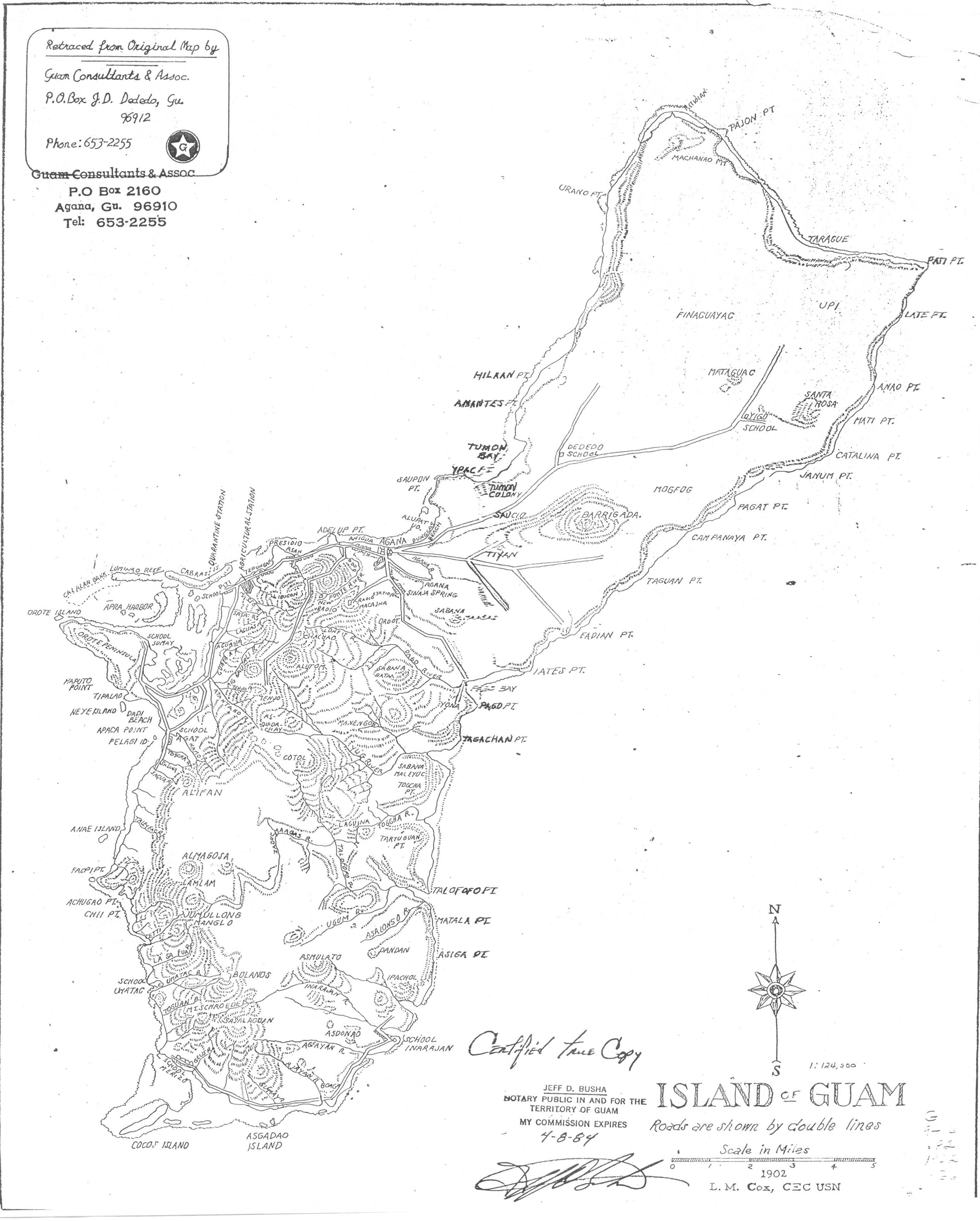
| 1902: L.M. Cox (CEC USN) – Island of Guam, 1:124,000 | Northern Guam Soil & Water Conservation District (NGSSWCD, Joseph Santos), Guam Department of Land Management (GDLM) | 1902 |
| 1913-1914: Strudevant et al. (Corps of Engineers) North Portion (Sheet 1 of 4), 1:25,000 | Northern Guam Soil & Water Conservation District (NGSSWCD, Joseph Santos), Guam Department of Land Management (GDLM) | 1913-1914 |
| 1913-1914: Strudevant et al. (Corps of Engineers) North Central Portion (Sheet 2 of 4), 1:25,000 | Northern Guam Soil & Water Conservation District (NGSSWCD, Joseph Santos), Guam Department of Land Management (GDLM) | 1913-1914 |
| 1913-1914: Strudevant et al. (Corps of Engineers) South Central Portion (Sheet 3 of 4), 1:25,000 | Northern Guam Soil & Water Conservation District (NGSSWCD, Joseph Santos), Guam Department of Land Management (GDLM) | 1913-1914 |
| 1913-1914: Strudevant et al. (Corps of Engineers) South Portion (Sheet 4 of 4), 1:25,000 | Northern Guam Soil & Water Conservation District (NGSSWCD, Joseph Santos), Guam Department of Land Management (GDLM) | 1913-1914 |
| 1915: City of Agana ~1915~, 1″ = 150′ | Northern Guam Soil & Water Conservation District (NGSSWCD, Joseph Santos), Guam Department of Land Management (GDLM) | 1915 |
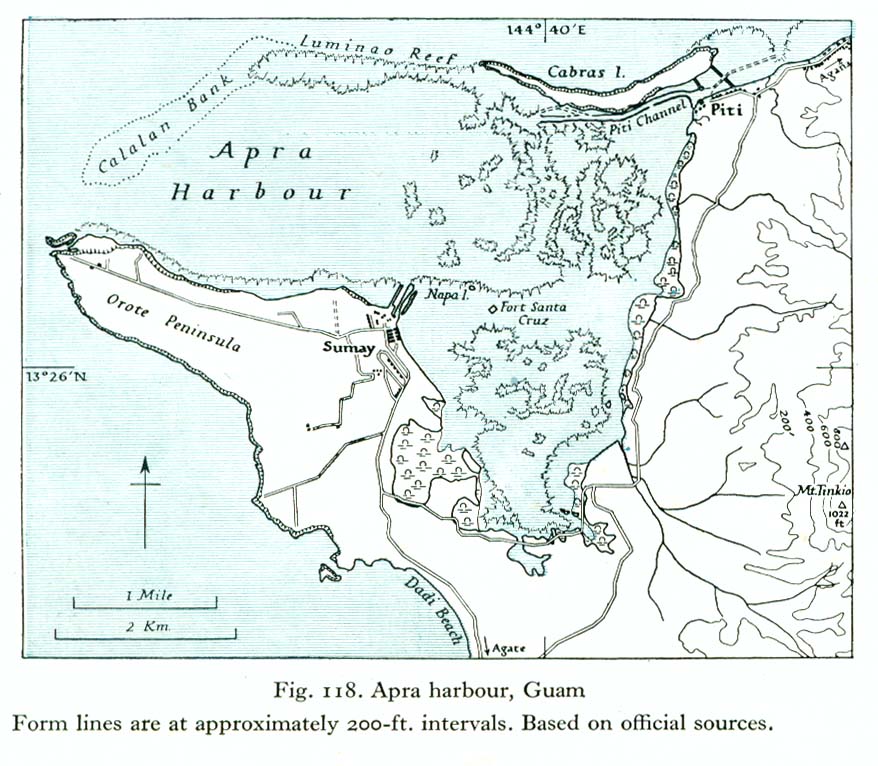
| 1938: Fig. 118. Apra harbour, Guam, From lines are approximately 200-ft. intervals. Based on official sources | Northern Guam Soil & Water Conservation District (NGSSWCD, Joseph Santos), Guam Department of Land Management (GDLM) | 1938 |
| 1939: Special Military Map of Island of Guam, War Plans Section, Marine Barracks, Quantico, Wa., 1:60,000 | Northern Guam Soil & Water Conservation District (NGSSWCD, Joseph Santos), Guam Department of Land Management (GDLM) | 1939 |
| 1944: Army Map Service (AMS), 2nd Edition, Map of Guam Island, US Army, Washington DC | Northern Guam Soil & Water Conservation District (NGSSWCD, Joseph Santos), Guam Department of Land Management (GDLM) | 1942 |
| 1942: Corps of Engineers (COE) Island of Guam (Uruno Point, Sheet 1 of 11) 1:20,000 | Northern Guam Soil & Water Conservation District (NGSSWCD, Joseph Santos), Guam Department of Land Management (GDLM) | 1942 |
| 1942: Corps of Engineers (COE) (1922 and 1942) Island of Guam (Ritidian Point, Sheet 2 of 11) 1:20,000 | Northern Guam Soil & Water Conservation District (NGSSWCD, Joseph Santos), Guam Department of Land Management (GDLM) | 1942 |
| 1942: Corps of Engineers (COE) (1922 and 1942) Island of Guam (Tumon Bay, Sheet 3 of 11) 1:20,000 | Northern Guam Soil & Water Conservation District (NGSSWCD, Joseph Santos), Guam Department of Land Management (GDLM) | 1942 |
| 1942: Corps of Engineers (COE) (1922 and 1942) Island of Guam (Apra Harbor, Sheet 5 of 11) 1:20,000 | Northern Guam Soil & Water Conservation District (NGSSWCD, Joseph Santos), Guam Department of Land Management (GDLM) | 1942 |
| 1942: Corps of Engineers (COE) (1922 and 1942) Island of Guam (Agana Bay, Sheet 6 of 11, v2) 1:20,000 | Northern Guam Soil & Water Conservation District (NGSSWCD, Joseph Santos), Guam Department of Land Management (GDLM) | 1942 |
| 1942: Corps of Engineers (COE) (1922 and 1942) Island of Guam (Pagat Point, Sheet 7 of 11) 1:20,000 | Northern Guam Soil & Water Conservation District (NGSSWCD, Joseph Santos), Guam Department of Land Management (GDLM) | 1942 |
| 1942: Corps of Engineers (COE) (1922 and 1942) Island of Guam (Pagat Point, Sheet 7 of 11) 1:20,000 | Northern Guam Soil & Water Conservation District (NGSSWCD, Joseph Santos), Guam Department of Land Management (GDLM) | 1942 |
| 1942: Corps of Engineers (COE) (1922 and 1942) Island of Guam (Agat Bay, Sheet 8 of 11, v2) 1:20,000 | Northern Guam Soil & Water Conservation District (NGSSWCD, Joseph Santos), Guam Department of Land Management (GDLM) | 1942 |
| 1942: Corps of Engineers (COE) (1922 and 1942) Island of Guam (Talofofo Bay, Sheet 9 of 11) 1:20,000 | Northern Guam Soil & Water Conservation District (NGSSWCD, Joseph Santos), Guam Department of Land Management (GDLM) | 1942 |
| 1942: Corps of Engineers (COE) (1922 and 1942) Island of Guam (Talofofo Bay, Sheet 9 of 11) 1:20,000 | Northern Guam Soil & Water Conservation District (NGSSWCD, Joseph Santos), Guam Department of Land Management (GDLM) | 1942 |
| 1942: Corps of Engineers (COE) (1922 and 1942) Island of Guam (Port Merizo, Sheet 10 of 11) 1:20,000 | Northern Guam Soil & Water Conservation District (NGSSWCD, Joseph Santos), Guam Department of Land Management (GDLM) | 1942 |
| 1942: Corps of Engineers (COE) (1922 and 1942) Island of Guam (Port Inarajan, Sheet 11 of 11) 1:20,000 | Northern Guam Soil & Water Conservation District (NGSSWCD, Joseph Santos), Guam Department of Land Management (GDLM) | 1942 |
| 1944: Army Map Service (AMS), 2nd Edition, Map of Guam Island, US Army, Washington DC | Northern Guam Soil & Water Conservation District (NGSSWCD, Joseph Santos), Guam Department of Land Management (GDLM) | 1944 |
| 1954: AMS (AFFE) Edition 1 Guam | Northern Guam Soil & Water Conservation District (NGSSWCD, Joseph Santos), Guam Department of Land Management (GDLM) | 1954 |
| 1984: Chase et al., Marine Physiography of the Commonwealth of the Northern Mariana Islands, Department of Interior, US Geological Survey | Northern Guam Soil & Water Conservation District (NGSSWCD, Joseph Santos), Guam Department of Land Management (GDLM) | 1984 |
